
If you're planning a development in Melbourne or regional Victoria, there's a good chance you'll encounter the question: do I need a flood impact assessment? The short answer is, it depends on your site, your planning overlays, and what you're proposing to build. Here's how to work it out.
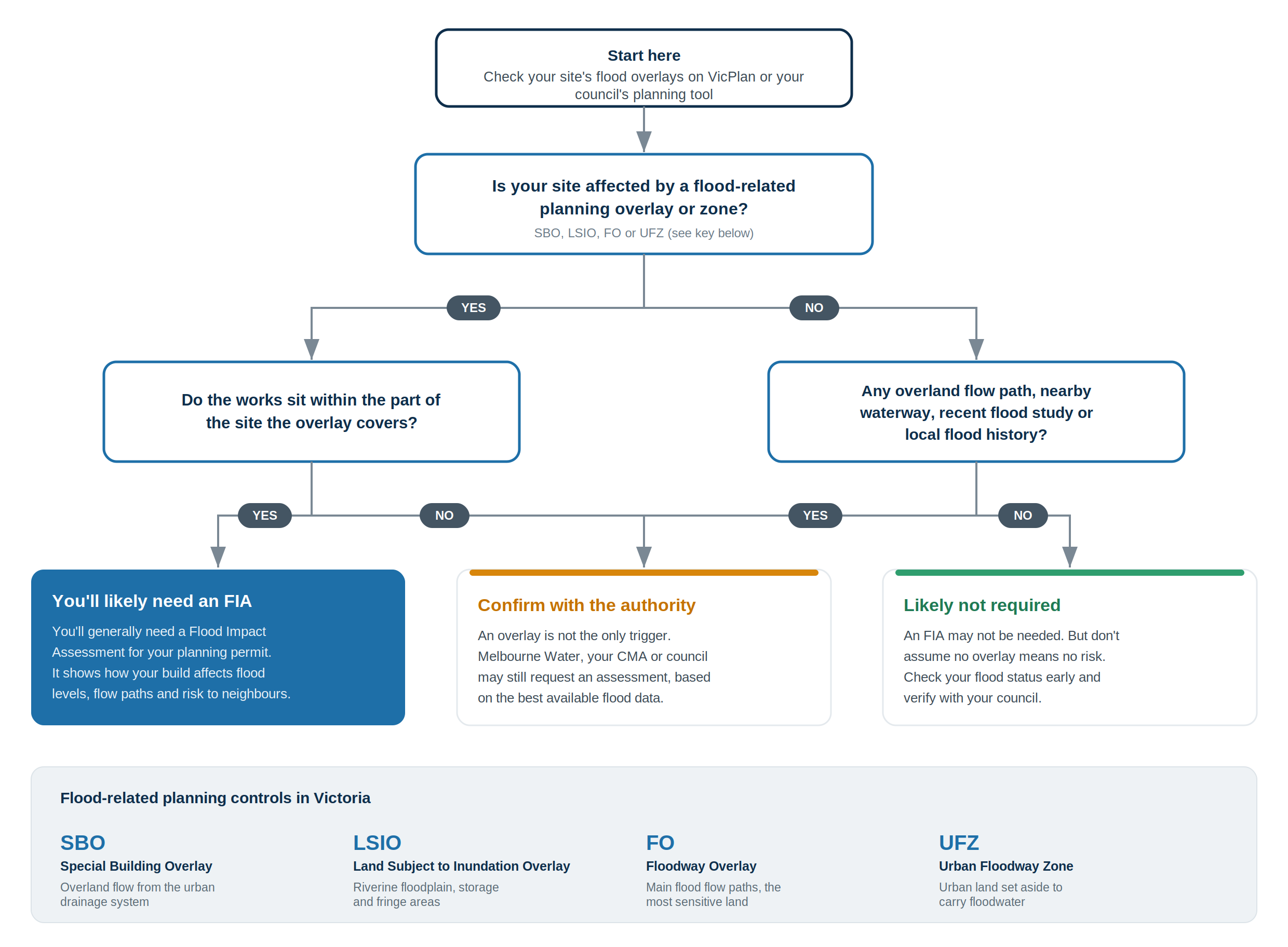
When is a flood impact assessment required?
A flood impact assessment is typically required when your property is affected by a flood-related planning overlay, most commonly a Special Building Overlay (SBO), Land Subject to Inundation Overlay (LSIO), or Floodway Overlay (FO). These overlays are applied by your local council based on flood mapping and indicate that your site may be at risk of flooding during significant rainfall events.
If your property has one of these overlays, you'll generally need a flood impact assessment as part of your planning permit application. The assessment demonstrates how your proposed development interacts with flood behaviour on and around the site, including whether it changes flood levels, redirects water, or increases risk to neighbouring properties.
But overlays aren't the only trigger. In some cases, councils or referral authorities like Melbourne Water or your local Catchment Management Authority (CMA) may request an assessment even if your site doesn't have a formal overlay, particularly if there's a known overland flow path, a nearby waterway, a recently completed study or a history of localised flooding in the area. Floodplain managers must base their assessment on the best available data.
Not sure where your site lands? Request a quote
Book a free 15-minute consultation
What does a flood impact assessment involve?
A flood impact assessment typically includes hydrological and hydraulic modelling of your site and its surroundings, an analysis of existing flood behaviour (depths, velocities, flow paths) against the estimated current and future 1% AEP flood event climate (SSP3 2100) scenarios, modelling of the proposed development to assess any changes to flood behaviour, an assessment of flood risk to the proposed development itself, and a compliance check against the relevant planning scheme requirements and guidelines, including Australian Rainfall and Runoff (ARR) and any applicable council or authority standards.
The assessment is usually prepared by a specialist flood engineer or qualified hydraulic engineer and submitted as part of your planning permit application. The referral authority, Melbourne Water in metropolitan Melbourne, or the relevant CMA in regional areas, will review the assessment before providing their response to council.
What happens if my site doesn't have an overlay?
Don't assume that no overlay means no flood risk. Flood mapping across Victoria is continuously being updated, and some areas have flood risks that haven't yet been captured in planning scheme overlays. Council planners may still flag flood concerns based on local knowledge, topography, or proximity to waterways.
If you're purchasing a property or starting early-stage feasibility work, it's worth checking your site's flood status before committing to a design. You can check planning overlays through VicPlan or your council's online planning tools, but a conversation with a flood engineer early in the process can save significant time and cost down the track.
What if I don't get one when I need one?
Submitting a planning application without a required flood assessment will almost certainly result in a request for further information from the referral authority, adding weeks or months to your approval timeline. In some cases, applications are refused outright because flood risk hasn't been adequately addressed.
The more costly scenario is when flood issues are discovered after a design has been finalised. At that point, redesigns, re-modelling, and re-submission can add months of delay and tens of thousands of dollars in additional costs. Getting the right advice early is significantly cheaper than fixing problems late.
How long does a flood impact assessment take?
Timeframes vary depending on the complexity of the site and the scope of modelling required. A straightforward residential assessment on a well-mapped site might take four to six weeks. More complex projects, large subdivisions, commercial developments, or sites with limited existing flood data, may take longer, particularly if new hydrological modelling is required from scratch.
The referral authority's review period sits on top of this. Melbourne Water and CMA typically responds within a statutory timeframe, response times can vary depending on workload and the complexity of the application.
How SWM Consulting can help
We prepare flood impact assessments for developers, builders, architects, and homeowners across Victoria, South Australia, New South Wales, Tasmania and Queensland. Our approach is to engage with authorities early, identify potential issues before they become problems, and deliver clear, defensible reporting that meets council and authority requirements, so your project moves forward without surprises.
If you're unsure whether your project needs a flood assessment, get in touch and we'll give you an honest answer. Sometimes the answer is no, and we'll tell you that too.
Book a free 15-minute consultation
FAQs:
Question 1: When is a flood impact assessment required in Melbourne?
Answer: A flood impact assessment is typically required when your property has a flood-related planning overlay such as a Special Building Overlay (SBO), Land Subject to Inundation Overlay (LSIO), or Floodway Overlay (FO). Councils or referral authorities may also request one if there is a known overland flow path, nearby waterway, or history of localised flooding.
Question 2: How long does a flood impact assessment take?
Answer: A straightforward residential assessment typically takes two to four weeks. More complex projects such as large subdivisions or commercial developments may take longer, particularly if new hydrological modelling is required.
Question 3: How much does a flood impact assessment cost?
Answer: Costs vary depending on the complexity of the site and scope of modelling required. Contact SWM Consulting for a quote tailored to your project.